The introduction of drones has expanded the possibility of receiving a greater range of information by having aerial drones monitor areas that were previously difficult for people to see.
Security and surveillance have moved beyond simply setting up a stationary camera. The introduction of
drones has expanded the possibility of receiving a greater range of information by having aerial drones monitor areas that were previously difficult for people to see. Having an eye in the sky allows for better security and safety as
drones can quickly spot threats or incidents and send out alerts in different settings from industries to cities.
The benefits that aerial drones bring can also become a security threat in some areas. Unwanted drones are an issue for highly protected facilities if they are flying around the perimeters. To counter this problem, drone detectors can be set up to detect suspicious objects and send messages or alerts to users that will inform them of drones flying into the restricted range. Some detectors possess features that can recognize the model of the drones or identify it as a bird.
Nightingale Security Robotic Aerial Security
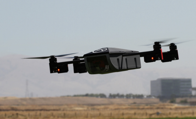
Nightingale Security provides Robotic Aerial Security for corporations. The comprehensive service consists of drones, base stations and powerful mission control software — all working together to provide autonomous, 24/7 physical security using real-time aerial surveillance cameras and data gathering sensors.
Key Features:
- Designed specifically for security applications
- Stationed on-site for rapid response
- Always on duty and ready 24/7 to patrol the facility
- Streams live video to security team via PC and mobile devices
- Object recognition and following
- Autonomous navigation to the point of interest
Drone Detector DD610AR Stationary Drone Detector
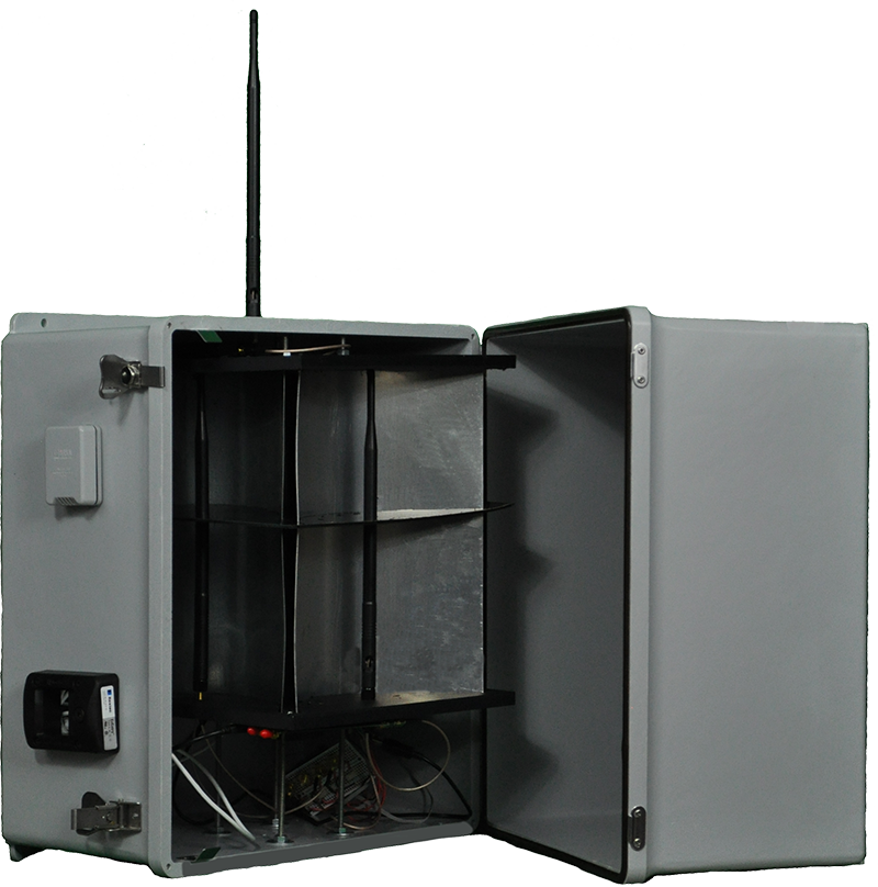
The DD610AR Drone Detector is a high sensitivity device designed to detect recreational and commercial drones up to one kilometer. DD610AR provides advance notice of drones commonly used by criminals and terrorists. Alerts are sent to the user which can be linked to alarms and security response teams. Forensic data, such as a unique identifier for an intruding drone, is preserved for legal proceedings. Custom Application Programming Interfaces (APIs) allow for easy integration with existing systems.
Key Features:
- Advanced warning of drones used by unauthorized operators
- For centralized facilities or perimeter monitoring
- Integrates into existing zone-based alarm systems with dry contact relays
- Open API for integration into operation centers and security systems
- Operating temperature range -76/274° F (-60/134° C)
DeTect HARRIER DSR-200 Drone Surveillance Radar
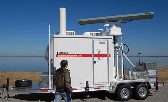
Cooperative and non-cooperative drone and small unmanned aerial vehicle/ system (UAV/UAS) detection, tracking, identification and intrusion alerting. Ideal for airports, power plants, industrial plants, public events and other sites that require airspace intrusion control for facility security and public safety.
Key Features:
- Classification of drones (quadcopter, helicopter, RC aircraft) and non-drones (birds)
- Automatic operation with user-definable risk alert zones and intrusion perimeters
- Real-time track plotting to identify probable drone launch and control sites for interdiction
- Optional panoramic or cue-to-target camera integration
- Multi-functional for simultaneous detection of drones and conventional aircraft (ultralights, helicopters, small-to-large aircraft)
- Full remote control and real-time information display (radar and video) for multiple users through secure network and web displays
Ascending Technologies AscTec Falcon 8
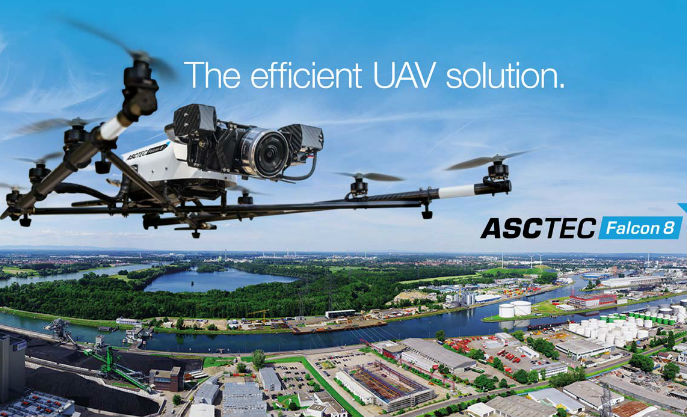
The AscTec Falcon 8 went into serial production in 2009 and has since been used globally for professional applications. For projects, the octocopter offers precision and safety with the reliable AscTec High-Performance GPS and the new control unit AscTec Trinity. It weighs in at a mere 2.3 kilograms of takeoff weight and works with maximum efficiency in the air – on- and offshore, even in challenging conditions.
Key Features:
- Fully automated flight routes in 2D and 3D are exactly reproducible by waypoint navigation, resulting in great ground coverage and reliable information
- Auto-functions for economic efficiency: up to 360° spherical or cylindrical panos, Point-of- Interest (POI) imaging and Circle-of-Interest (COI) imaging
- Permanent live flight check: the flight system sends all relevant flight data to the mobile ground station in real time, delivering visual and acoustic signals
- Enhanced safety in case of emergency: in case of total link loss, a safety mode takes over the controls to initiate an automatic landing maneuver. Users can choose between “Direct landing”, “Come home straight” and “Come home high”
- Direct control, settings and telemetry viewed in real time. Users have total control over the flight system and camera at any time. Zoom, aperture or exposure time can be changed by the user or when changed light conditions require spontaneous resetting
Dedrone DroneTracker Multi Sensor
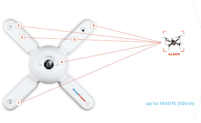
DT Multi Sensors can be mounted permanently to facades or special poles, in order to survey a defined section of the sky 24/7. The sensors are designed to be used in a variety of locations including prisons, industrial facilities, government facilities and private buildings. It is equipped with a wide range of detectors such as acoustic and Wi-Fi sensors.
Key Features:
- Microphones have a reach of 50-80 meters; civilian UAVs have typical acoustic characteristics that are used for reliable detection
- Integrated Wi-Fi-sensor detects WLAN drone signals which allows for identification of certain drone models and even single devices
- Sensors can be equipped with an infrared camera; the data is interpreted by means of enhanced image analysis methods
- Each DroneTracker is equipped with a daylight camera that uses enhanced image analysis functions to analyze the live video feed
FLIR Aerial First Responder Kits
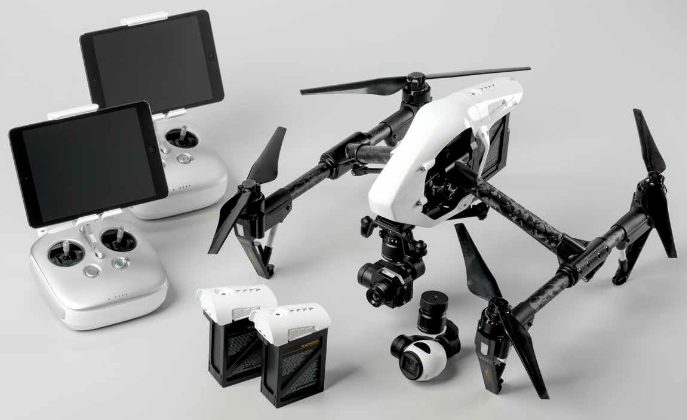
By combining the flight stability, gimbal technology, mobile app integration and image transmission of the DJI Inspire 1 with
FLIR Systems’ thermal imaging technology, these packages provide solutions for reliable, rapid-deployable aerial thermal imaging. They are particularly suitable for firefighting support because they give incident commanders the ability to see through smoke and keep track of their personnel in large fire scenes. They are also must-have kits for rapidly deployed SAR missions regardless of the time of day.
Key Features:
- Airborne thermal imaging support at the users’ fingertips for every call
- Ability to see through smoke and keep an eye on personnel in complex fire scenes
- Expanded SAR operations day and night
- Monitors roof conditions to reduce risk to firefighters
- Highly-integrated, easy-to-fly aircraft with drone app for live video, camera control and digital recording
- Complete package that includes everything users need to get flying in minutes
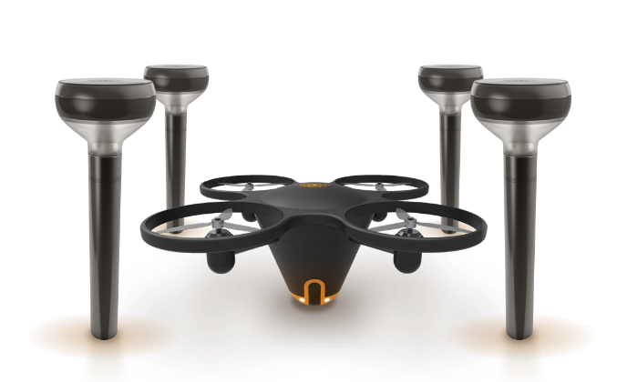
Sunflower Home Awareness System
The Sunflower Home Awareness System combines outdoor sensors with an aerial camera for a complete view of what is going on around the home. Sunflower Smart Lights learn the property’s routines, deterring unwanted visitors with light and sound. When there’s unusual activity, the Smart Lights work with the Sunflower Flying Camera to identify what is happening.
Key Features:
- Clear views: when the Smart Light detects something strange, the flying camera can be sent to the point of interest for live video
- Insightful alerts: different events require different responses. Apps can be pre-set to send alerts or handle things on its own
- Sunflower Smart Light 360° motion sensors detect movement; vibration sensors identify footsteps
- Sunflower Flying Camera uses differential GPS for precise navigation around the property